 Religious geometry in prehistory
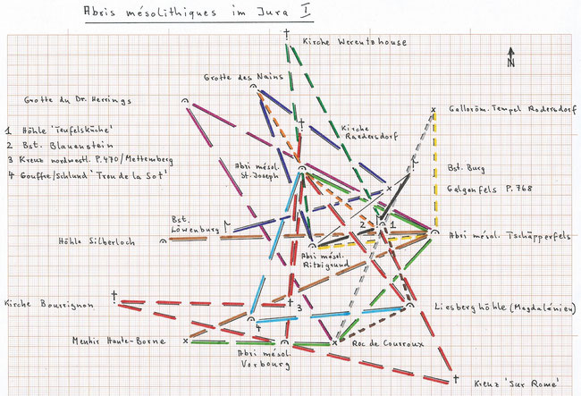
This study seeks to demonstrate that in the border area Switzerland/France already in the Mesolithic Age some rock shelters (French:'Abris') were likely artificially prepared to obey precise
geometric relations between them.
This was already advanced as a conjectural opinion in the book Religioese Geometrie in der Urgeschichte (p.37).
These mesolithic rock shelters were therefore not (or not only) resting places where the hunters repaired their hunting tools, but a sort of 'cult places', maybe as partially artificial
half-caves successors to the caves (which were hardly inhabited permanently ...).
As a result we should somewhat correct our ideas about the mesolithic man: although not having yet ceramics (however, first odd findings exist) nor cultivation of cereals nor cattle farming, he
might have dwelt in permanent huts and was already culturally quite advanced; one should be reminded of the mesolithic cult place Goebekli Tepe in Turkey 8000 BC.
From the deep gorge/abyss ('gouffre') 'Trou de la Sot'/Delémont JU (592.065/248.825; today filled up with rocks) are the mesolithic rock shelter 'St.Joseph'/Lutter (F) (594.600/256.350) and the
half-cave 'Liesberghoehle'/Liesberg BL (599.985/249.495), dating back to the Magdalénien, exactly equidistant (7.91 km, always measured horizontally).
The straight line 'Trou de la Sot' - 'Liesberghoehle' goes precisely through the chapel Riedes-Dessus/Soyhières JU (not indicated in the graph).
The rock shelter 'St.Joseph' is then equidistant (8.67 km) from the 'Liesberghoehle' and from the mesolithic rock shelter 'Vorbourg' (Béridien)/Delémont (593.735/247.665; very much later a castle
was built there, a fairly rare case).
The same distance of 8.67 km can be found another five times (!) and interlinked: between 'Vorbourg' and the church in Bourrignon JU as well as between 'Vorbourg' and the cross 'Sur
Rome'/Courchapoix JU (602.235/245.650), and church Bourrignon, 'Vorbourg' and cross 'Sur Rome' are on a straight line ! Furthermore between church Bourrignon and a cross northwestern of
P.470/Mettembert JU (593.965/249.485), and between this cross and the church of Raedersdorf (F), also between the cross 'Sur Rome' and the former castle 'Blauenstein'/Kleinluetzel SO
(598.310/253.420).
(The straight line 'Vorbourg' - former castle 'Blauenstein' goes straight over the church Soyhières; not indicated in graph.)
A straight line leads from the mesolithic rock shelter 'Ritzigrund'/Roggenburg BL (595.100/252.425) over the former castle 'Blauenstein' to the cave 'Teufelskueche' (devil's kitchen)/Kleinluetzel
(598.610/253.500). 'Blauenstein' is equidistant (3.34 km) from the mesolithic rock shelter 'Ritzigrund' and from the former castle 'Burg'/Burg BL (600.150/256.230); the straight line
'Ritzigrund' - 'Burg' leads over 'Galgenfels' (gallows rock) P.768/Burg (a strange name; although there is a wide view from this rock, it was hardly a place for gallows ...).
The cave 'Grotte des Nains' (dwarfs' cave)/Sonderdorf (F) (592.200/260.405) is now equidistant (8.42 km) from 'Galgenfels' and from the mesolithic rock shelter 'Ritzigrund'; the same distance
between 'Galgenfels' and former castle 'Loewenburg'/Pleigne JU (where very old artefacts were found).
The church in Werentzhouse (F) is then equidistant (10.37 km) from the mesolithic rock shelter 'Ritzigrund' and from the cave 'Teufelskueche'; the straight line church Werentzhouse
- 'Ritzigrund' goes exactly through the mesolithic rock shelter 'St.Joseph' !
Already reported in the above mentioned book is the following geometric relation: the mesolithic rock shelter 'Tschaepperfels' (hat-like rock)/Roeschenz BL (601.250/253.105) is equidistant (7.36
km) from the mesolithic rock shelter 'St.Joseph' and from 'Roc de Courroux'/Courroux JU (596.200/247.685), most likely a prehistoric 'cult place'. The same distance again between 'Roc de
Courroux' and the menhir 'Haute-Borne'/Bourrignon (588.790/247.755).
The mesolithic rock shelter 'Tschaepperfels' is equidistant (13.51 km) from this menhir and from the cave (abyss) 'Silberloch' (silver hole)/Pleigne (587.705/252.635).
The straight line menhir 'Haute-Borne' - cave 'Silberloch' leads to the church in Winkel (F), and the menhir is equidistant (8.99 km) from this church and from the chapel
Riedes-Dessus mentioned above (both not indicated in graph).
The cave 'Grotte du Docteur Herrings'/Bensdorf (F) (588.815/259.695), which cannot be dated for now, is equidistant (14.02 km) from 'Roc de Courroux' and from the mesolithic rock shelter
'Tschaepperfels'.
'Tschaepperfels' is also equidistant (6.14 km) from 'Ritzigrund' and from the former gallo-roman temple Rodersdorf SO (601.170/259.265), the cave 'Teufelskueche' from this former temple and from
'Roc de Courroux' (6.26 km) and 'Liesberghoehle' from 'Roc de Courroux' and from 'Teufelskueche' (4.17 km).
Finally, the mesolithic rock shelter 'St.Joseph' is equidistant (4.69 km) from the former castle 'Blauenstein' and from the cave 'Grotte des Nains'.
For all these many and often probably mesolithic geometric relations it is striking to find a large number of equidistant (isosceles) triangles beside relatively few straight lines.
Write a comment